Search Results
13 results found with an empty search
- Nessebar, 3000 years of history
A millennial citadel-museum, located at 330 km from Bucharest (approx. 5 h by car) and 35 km north of Burgas, in the region with the same name (Burgas), Nessebar is among the oldest cities in Europe. The settlement was founded by the Thracian king Melsa (71 BC), who named it Melsebria ('city of Melsa'). The town was successively occupied by Greek, Roman and Byzantine settlers, who renamed it Mesemvria, or Mesembria. The present name is the result of phonetic transformations and has been accepted since 1934. In 1956, it was declared a reserve of urban architecture and archaeology of national importance, and 27 years later (in 1983) it was included on the UNESCO World Heritage List. The history of the fortress begins in 3200-3000 BC, in the Copper Age. The ancient city grew over an area twice as large as it is today, parts of walls being found underwater, at 80 m from the shore. The old city is 850 m long and 350 m wide and it is separated from the new city by a 1 km long isthmus. Over the centuries, successive populations have built around 40 churches, Nessebar being considered the town with the most churches per population. More than half of these are renovated or turned into museums. The most representative cultural establishments on the territory of the Old Town are: the museums of archaeology and ethnography; St Stephen's Church (with frescoes from the 11th-17th centuries); the Old Metropolitan Church (5th century), St Sophia which is built on the ruins of the ancient Temple of Apollo; the Kraymorska Basilica (Eleusa); the Church of Christ Pantocrator in the center of the island (12th-14th centuries); the Church of St Mother of God (1884). The most beautiful and well-preserved murals dating from the 14th-18th century enrich the interior of the New Metropolitan St. Stephen's, a three-nave basilica. This also houses an archpriest's throne and an iconostasis, both carved in wood by Renaissance craftsmen. As for the population, it should be noted that there have always been changes in its structure, from a majority Greek population to a majority of Slavs and Bulgarians. A remarkable development of the city took place during the reign of the Bulgarian King John Alexander (1331-1371), who encouraged literature, art, architecture and constructions. This made the city to prosper. Inevitably, it came to be coveted and conquered, although its wealthy inhabitants offered a great deal of money to be free. This until its final conquest for nearly 5 centuries by the Ottomans in 1453. At the beginning of the Ottoman rule, the city suffered looses and destruction, stagnating in development, forcing the enslaved population to gradually adapt, relying mainly on the maritime trade. The town was revived during the Renaissance (18th-19th centuries). Thus, the poor fishermen cottages were gradually replaced by large, beautiful buildings, true monuments of the Bulgarian Renaissance architecture. These form the so-called urban houses on the Black Sea coast, adapted to the local climate and way of life: their ground floor is made of stone, with one or two levels or two outside exits, built of wood and rest on solid wooden beams. In the basement, on the ground floor or in separate outbuildings are cellars, wine stores, spaces where fish are dried, or where fishermen repair their nets. Strong winds did not allow open verandas upstairs, that were common in Greece. Typical houses of Nessebar feature the so-called "Chardak", an enclosed veranda. About 60 houses have been preserved or renovated in this architectural style. Nessebar is has three windmills from the same late Renaissance period, which coincided with an economic revival and the emergence of wealthy guilds of craftsmen and merchants. Fishing has always been a basic occupation of the inhabitants; women made nets and men fished with large, specific boats called "Alaman". Another traditional occupation was viticulture, each house having its own wine cellar. Tourism developed in the twenties, with the construction of holiday homes for wealthy families. After 1970 most of the small family businesses that are present today had developed, many souvenir shops, embroidery, leather-work emerged. Most of these shops are located on the ground floors of the residents' houses. The old town is a labyrinth of small, irregular, wood-scented, granite-paved streets with traditional mehanes (inns) serving fish and seafood and also the Balkan cuisine. Lots of taverns, cafés and hand-made workshops line over these narrow streets. The entrance to the old town is also remarkable, through a gate that pierces the 8 m high and 100 m long old city wall and the medieval amphitheater. The photos we took captured the architectural beauty of the city, the open landscapes towards Sunny Beach, Sveti Vlas and Elenite on one side and Burgas on the other side. Photos also highlight the colors of the sea and the sunset, the night lights, and the taverns. Other leisure possibilities are offered by the boat trips across the sea to the surrounding resorts, or by the beaches on the shore, by the traditional restaurants with their own special menus, by the amusement park or the circus situated in the new town. On St Mary's Day, the 15th of August, the municipality organizes a town celebration with fireworks, light shows and several traditional music concerts. As for accommodation, there are plenty of choices, both in the old and new part of the city. We recommend few places to stay in the old part of the town, for its bohemian air and the quiet that settles in the evening: St. Nikola's, Panorama Blue, St. John's and last but not least the St. George Hotel, where we stayed most of the time with our welcoming hosts George and Tony. Nessebar is certainly a beautiful holiday destination for all travelers.
- Nera Canyon - Beusnita Waterfalls
This protected area, which includes The Lake "Ochiul Beiului" (Sultan Eye), is located in Banat, Caras Severin county. Over a distance of 23 km, the Nera River carves its way through the limestone, forming the longest canyon in Romania. We visited the area at the end of October. Along the valley of the Bei river runs a lush temperate forest with many endemic species and rich in fauna. The path following the course of the river is flanked by dense and in places impenetrable forest. Apart from our whispers, the silence of the forest is pierced by the sound of the water as it crosses thresholds. Very soft in general, the clear turquoise-green water forms standing water meshes in its meanders. The narrow road leads to the Beusnita 1 waterfall, the smallest of the three waterfalls, and then continues to "Ochiul Beiului" (Sultan Eye in English), a lake of a 3.6 m deep and a 15 m in diameter, with a clarity and color that leaves you astonished. The camera's lens captured the special color of the crystal-clear water: a turquoise blue with shades of green. The images speak for themselves, making words unnecessary. The spring that feeds the lake never freezes because of the constant temperature, between 4 and 8 degrees Celsius. We hardly leave this magical place and continued our journey along the course of the river, cutting through the dense forest and effectively avoiding salamanders that had emerged from their shelters due to the wet weather. Then, we marveled in front of the second waterfall (15 m high) that forms the Beusnita 2 waterfall. Animal and human figures, fairy-tale characters reveal their millennial presence, carved into the rock. I managed to capture, in wonderful photos, the raw green of the moss that covers the rock and the drops of water that keep it alive. I also captured (by searching the right angles) the expressive figures carved by water and nature in the limestone. The late hour did not allow us to continue our journey and discover the last of the three Beusnita waterfalls. On the way back, we enjoyed the shades of green of the virgin forest, which forms the 36758 ha of The National Park. It will certainly not be the last trip we will made in this beautiful virgin region.
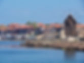
- Sozopol, the pearl of the Bulgarian sea coast
Sozopol is the oldest human settlement on the Bulgarian Black Sea coast. The town is located at 350 km from Bucharest and 35 km south of Burgas. It was founded in 610 BC by the ancient Greeks on a rocky peninsula with high cliffs, calling it Apollonia Pontica. The Roman invasion in 72 BC made this Greek colony prosper. In the early fourth century, due to turbulence within the Roman Empire, the city of Apollonia was rebuilt under the name of Sozopolis or " The City of Salvation". Being close to Constantinople, the Romans were forced to build fortifications and enclosing walls, including watchtowers along the rocky coast. Barbarian people (especially the Huns) conquered and burned the city, making it necessary to rebuild these fortifications. Sozopol became thus a strategic military center and one of the most important ports on the Black Sea coast, with a flourished trade. In 1453 the town was conquered by the Ottoman Empire, which led to its decline to the status of a fishing settlement. The historic part of the town retains a romantic, majestic, enigmatic air, with stone streets bordered by stone houses decorated with wooden balconies. The town is housing several churches, museums and more than 45 architectural monuments from the National Revival period. The southern wall and the Citadel Tower have been preserved, as well as as the Thracian necropolises dating from the Greek occupation. Cafes, restaurants, small souvenir shops of local craftsmen, are spread out in large numbers, both along the coastline and on either sides of the cobbled streets. The camera lens captured the enchanting scenery, the beautiful sunsets and amazing colors of the sea, both from land and from the deck of the boat we circled the peninsula with. We had the opportunity to visit this bohemian town in both spring and summer, enjoying the history and the architecture of the place. Each time we accommodate close to the historic center, the harbor and the beach. Radik Hotel is a cheap, chic and very well located place where one can have a great time.
- Olympus Riviera. Platamon
Platamon is a resort town located in Greece on the Riviera of Olympus, in central Macedonia. Platamon is one of the plethora resorts, in Thermaic Gulf, that lie at the foot Olympus Mountain. All are famed for their sprawling beaches starting with Paralia Katerini, continuing with Olympic Beach, Leptokaria, Skotina and ending with Nei Pori. Platamon in Greek means "The Long Beach". Some sources give as the origin of its name, the sycamore trees that majestically spread their crowns over the houses with colonial architecture. The town is also a harbor for yachts. Along its shores, there are many restaurants where you can serve fish dishes. Platamon has a permanent population of about 1500 inhabitants, but in the summer, when tourists arrive (mostly from Serbia and Romania, but also from Greece) the population reaches 120 000. The town's big attraction is the Venetian Castle that dominates the surroundings, situated on a hill on the Aegean coast. We discovered this holiday destination by chance 5 years ago. The owner of one of the resorts on the Olympic Riviera, Nikos Bozas, was presenting his properties on one of the Romanian TV channels. Being also a Romanian citizen, Nikos runs the Niko Paradise hotel and the nearby Bozas villa togeather with his son Stelios Bozas. They also run a Romanian-Greek travel agency: Platamon Travel. Until then we had never set foot in the land of the Olympian Gods, now having the opportunity to spend The New Year's Eve at the hotel owned by the Bozas family. After a wonderful week there, at the turn of the years, the next visits came naturally over following years. And there were not a few, but seven or eight. The landmark of the resort is the castle built by the Byzantines in the 10th century, between 1204-1222 and later fortified under Venetian and Ottoman rule. According to early historical sources, the ancient city of Heraklion stood on this site. The castle enjoys a very important strategic position on the road connecting Macedonia and Thessaly via the Tempi Valley. The construction of the castle was started by the Frankish King Boniface of Monferatikos in 1205, on the ruins of an existing Byzantine castle on that hill. For the first time it was mentioned in writings from the 13th century, when the Franks restored the fortifications, followed by the Byzantines in the 14th century and by the Venetians in the 15th century. After the fall of Constantinople and the Fourth Crusade, the castle was under Byzantine occupation until 1470, when it was conquered by the Ottomans, under whom it played an important role in the 14th century. The castle can be visited all year round and is very well preserved and restored. Another important destination for tourists staying in and around Platamon is the traditional village of Palios Panteleimon, at 6 km away. The asphalted road meanders along, revealing wonderful views of the sea. The architecture of the area reveals stone constructions, including paving stones covering the narrow and winding streets on steep slopes, which open some exceptional views of both the Aegean Sea and Olympus Mountain. The mountain slopes are housing traditional stone and wooden buildings, restaurants, taverns, and small craft workshops offering painted pottery, leather goods, jewelry and souvenirs, as well as locally made clothing. As regular visitors to the place, we made friends, seeing each other again being a pleasure, an occasion for jokes and hugs and little hand-made gifts. We highly recommend the café situated next to the church, in the center of the village and for dinner taverns that border it. We often made visits here for several hours, coming from Platamon, for lunch or dinner, after which we took wonderful walks along the narrow alleys, capturing exceptional photo views. The camera lens captured enchanting views and magnificent sunsets unfolding to the eye behind the imposing Olympus. The colors are stunning, delighting the eye of the viewer. Platamon is located 786 km from Bucharest and 106 km from Thessaloniki, on the E75 express road and Egnatia Odos motorway, from the Promachonas border to its destination.
- Bigar Waterfall
This is one of the most beautiful waterfalls in the world. It is situated where The 45th parallel crosses Romania. Located on the national road DN57B, on the Miniș Valley (Caras Severin County), at 452 km from Bucharest, the most beautiful waterfall from Romania is fed by the Bigar spring. The water, rich in limestone, springs from the underground, from a 50 m high rock, and crosses the Bigar cave, flowing into the Minis river. The short road to the spring is also very beautiful, the stony path ending with a wooden bridge (which crosses the river), a bridge that connects the road with the entrance of the cave. We had the privilege of visiting the region in the end of September, when the autumn chromatic was very beautiful. The period benefited from some rainfall, the day of visiting being also a wet one. This allows us to admire a wonderful view of the waterfall and to take spectacular photos at sunset. The legend says that those who drink water from the famous waterfall, will benefit of love forever. In 2013 the site The World Geography considered Biger waterfall the most impressive world's waterfall in a ranking of the most beautiful waterfalls. In 2000, the Biger waterfall was declared protected area of national interest, being part of the Nera Canion National Park. Unfortunately, on June the 7th 2021, a part of the waterfall collapsed. The travertine and muscles that had accumulated over the time had increased in size and weight, and the ground gave up. (https://www.hotnews.ro/stiri-mediu-24845246-cascada-bigar-prabusit.htm).
- A sleigh ride through the Romanian Cold Pole
Who has never dreamed about a ride with a horse-drawn sleigh in an enchanting land? The Ghimes Valley is located in Harghita County, Romania and includes three localities: Lunca de Sus, Lunca de Jos and Ghimes Faget. Local people is very friendly, welcoming and warm, although they are at the Romanian Cold Pole. The area has a peculiarity: the Hungarian population calls itself "Ghimes Ceangai" to differentiate them from those of Moldova. A characteristic of their lifestyle is that in spring they move up in the mountains with the animals and in the autumn they move back down to the village. Thus, their houses are spread over large areas. The horse-drawn sleigh rides - in winter, or horse-drawn carriages - in spring and summer, are the main attraction of the area. The picturesque rides take place at the foot of the Ciuc Mountains in an enchanting land. The locals dedicate their time for hiking horse-drawn carriages. This type of ride lasts about 3 hours, paused by a picnic break. Traditional products are served at the table: potato bread with rye, ham with onions and sheep cheese accompanied by the local brandy. The locals prepare a tasty goulash in a big cauldron adding the famous potatoes locally grown, and serve it with pickles and the same great Romanian brandy (of 40 dgrees). The area is also known for its gas pits, specific to the volcanic soil, with sulfur emanations used for therapeutic purposes, the region being also called the Land of Volcanoes. The park with wild animals from Ivo covers 320 ha and it is surrounded by mountains. Here, we can admire animals like the deer and the mouflon. We can reach this natural Park by following the route of Bucuresti-Brasov-Odorheiul Secuiesc with destination of Izvoarele region.
- Blue Eye, Albania (Shqiperia)
Blue Eye is a natural phenomenon and an attraction for tourists and it is situated in the southern part of Albany, close to Sarande town. In September 2019 we had a very beautiful adventure in Albania. It is a fascinating country that I want to describe in stages through the places visited. From the town of Sarande the road continues to the village of Muzine. Located in an enchanting natural park, guarded by sycamore and oak forests, the springs of the Bistrice river travels 25 km until it empties into the Ionian Sea. From a karst pit, which seems bottomless and to which many divers could not measure its real depth, spring 18 waters from the depths of the earth: Blue Eye (Syri i kalter). Seen from above from the platform, the karst pit looks like in the photo below: The water has unreal shades of blue-green-turquoise, bubbling quietly to the surface. The Albanians built a metal platform that forms a terrace, just above the "Blue Eye" lake, so that tourists can immortalize, from the best position, this magical natural phenomenon. As the natural park, it must be specified that the entire forest is permanently green, due to the positive temperatures throughout the year. But the water, with its unreal color is very cold, with a temperature below 8 degrees. Near the river we can sit and enjoy a rich meal and contemplate the unusual view chromatic.
- Reservation and Lake Saint Anne
In Harghita County, Romania, there are two volcanic craters, around which there is a unique European natural reservation on an area of 240 ha. In one of these craters the only volcanic lake in Romania was formed: Saint Anne Lake, and in the second lake there is an oligotrophic swampy area of 80 ha, namely Tinovul Mohos, located at 1050 m altitude. The surface of this bog is almost 4 times larger than that of the Lake St. Anne, and its depth reaches 20 m in some places. The birth certificate of this reservation is lost in the mists of time, 30,000 years ago. The crater that houses the Tinov erupted first, forming a lake. The volcanic ash thrown when the second crater erupted, clogged this lake, forming the peat moss, which gives an almost black shade to the 20 meshes of water scattered on the surface of Tinov. These dark meshes are not supplied with water, except by precipitation. Four of them have a unique feature: they have a double bottom in the shape of an amphora. The lake bed closes in the middle, then reopens to the second bottom, taking the shape of that amphora. Inside the Reservation there is a wooden path-walkway, on which specialized people are guiding tourists on 800 m to the two existing water holes along the path. Another history of the place leads us over the years 2012-2014, when the peat bog was attacked by xylophagous swamp insects, which destroyed a large part of the wild pines and especially the birches in the tree population. Tinovul Mohos is also known for its carnivorous plants such as Roua Cerului, nicknamed after an insect eater, but also the Peat Rosemary (pictured), a plant with 10 times more poisonous than Romanian "matraguna". Its poison leaves no traces, being undetectable in the body for 72 hours after death, after which it decomposes. All these, but also many others are told by local people in funny stories, by the guides of the Natural Park, most of them villagers. This natural reservation is located between the spa resorts Tusnad and Balvanyos the custodian being a local: Loti Baci. The 435 ha domain is owned by villagers, the tourism providing the financial resources for the maintenance of the reservation. For local people, the care and love for nature is on the first place.
- Stone Ravens
Stone Ravens is the name of the oldest Romanian cave-monastery. Located about 50 km from Pitesti town, Stone Ravens Monastery is situated in the Arges County, Jgheaburi village. A place of worship built directly into the rock, in a massive of 30 m high, a masterpiece of art in symbiosis with nature, which is also known as the "Stone Church". The Byzantine aspect makes specialists estimate that the establishment was made in the first millennium of the Christian era. This is the only place of worship in Romania with two functional altars on the same nave, each of them provided with a holy table and a cross. The church has two separate patron saints, one being the "Assumption of the Blessed Virgin" received during Neagoe Basarab reign, the second patron saint being "St. Peter and Paul", title received when the Church was consecrated in the first half of the eighteenth century. This church is architecturally related to the group of cave churches in Cappadocia, the architecture with two altars dedicated to a double patron saint, being characteristic to the Byzantine style. In the same time, the church is known as being founded by the Basarabians, containing the oldest painting ensemble in Romania, made at the end of the 13th century and the beginning of the 14th century, before the one from the Royal Church from Curtea de Arges. Stone Ravens Monastery also appears in the document from June 23, 1512 as the first documentary attestation of a nunnery from our country. The traveler climbs a few dozen old steps, to the tiny entrance (less than 1 m high) that connects the outside of the stone wall and the cave that opens inside. At the base of the steps is a small wooden chapel, over 130 years old, with a bell tower. What immediately amazes upon entering the rock is not only the excessive moisture (95%), but also the advanced stage of paintings degradation on walls. The ensemble is permanently degraded, never being renovated. The icons on wood are extraordinary, still resisting to the test of time. Outside, under the rock, there is an open space, the refectory of the monastery (the place where the meal was served) where it is said that Neagoe Basarab kept the judgments when he visited the place. Stone Ravens Monastery, together with Namaiesti Monastery and Negru Voda Fortress, form a triangle with sides of approximately 20 km. This geometric shape formed by the three places of worship is known as the "Sacred triangle of Arges". A legend of the place says that this huge rock would be the tomb of a giant and that next to it would have been a place of sacrifice of the Dacians. Above the the monastery rock archaeologists have discovered the traces of the Dacian Fortress Geridava, where the king of the Getae, Dromichete, would have lived for a while. Above the western wall of the cave church there is a Latin cross with a pyramidal head. The plateau above the rock can be reached by climbing some rudimentary steps made of wood. There, a beautiful panorama opens over the wooded hills and the surrounding mountains. The name "Ravens" originates either from the birds that make nests in the rock, or from the monks who lived in the caves (photo below). Our recommendation is to discover the narrow surrounding places, distinguished by the beauty of nature and the interesting shapes dug in the rock.
- Enchanted forest - Romania
An enchanted forest is covering Baraolt Romanian Mountains situated in Covasna County. At the end of October, in the middle of autumn, we took an itinerary in the mountains of Covasna county, starting from the resort Sugas Bai (from the base of the ski slope) to the peaks of Gurgau (1017 m) and Havad (1019 m) mountains, with a short stop in Benko glade, continuing to the village of Haghig. The photos will reveal you a fairy tale landscape, blurred and fierce, discovered through the rain and the excessive humidity. In our trip, we were accompanied by the shadows of a thick fog, which sometimes looks like an unleashing ghosts among the trees; the game of dancing mist revealed the deep darkness of the enchanting forest, freezing our hearts. As we climb the slope to the two peaks, the beech and birch forest let more place to the fir trees. Through the steam that arise from the ground covered by the multicolored autumn leaves, the forest doesn't allowed us to see into the depth. A strange darkness blocked the light, through the camera lens, and we hardly tried to penetrate the opaque fog wall to take pictures. The narrow path, covered with leaves on large sections, is opening to the plateau. Along the path to Benko we stumbled over many water holes and we encountered many multicolored mushrooms. The dense and enchanting forest leave place to a large view that delights our eyes with its spectacular and splendid colors of autumn. Descending from the plateau, the magic of the fir forest is replaced by the magic of the deciduous forest, until the end of the route: the village of Hagig. The whole itinerary delights the eye of the viewers and incites the professionalism of photographers.
- Cotmeana - the oldest Romanian Monastery
Cotmeana Monastery is located in the Arges County, at 5 km from the route between Pitesti and Ramnicu Valcea towns. Taking advantage of a very pleasant afternoon, at the end of November, we made a stop at the oldest church-monastery in Wallachia. The one who built for the first time, here, a wooden church, Cotmeana Hermitage, is Radu I, the ruler of Wallachia between 1377-1383. Later, this small church was devastated by a fire, the king Mircea cel Bătrân being the one who rebuilt this settlement between 1387-1389. The church has two patron saints: the Annunciation and the Beheading of St. John the Baptist. The first documentary attestation of the Cotmeana Monastery is related to the construction of the Cozia Monastery, another important foundation of Mircea cel Bătrân (Mircea the Old) inscribed in a deed from May 20, 1388. Archaeological excavations around the Monastery have revealed secular tombs of some old monks who were buried with a wooden cross and a brick at the top in the XIV century. The antiquities collection of the Argeș County Museum counts a treasure with gold coins, terracotta and ornamental discs discovered in this place. The church was restored by Constantin Brancoveanu in 1711 and later repaired between 1855-1857. But the history of the establishment also knew bloody periods, during the time of Mihnea cel Rău, due to the authoritarian policies of this ruler. In February 1510, the battle of Cotmeana between Mihnea cel Rău and the Craiova governor is mentioned, the former hardly escaping with life and finding refuge in Transylvania. What did we discover here? Inside the walls of the enclosure, provided with firing nets, there is the old settlement composed of the church and a wooden tower, which houses the oldest bell in Wallachia, a bell donated by governor Dragomir in 1383. A special story from the First World War: this bell was the only one that was saved from melting, all the others having to be ceded to Budapest to Austro-Hungarian Empire. Next to the old church there is a Chapel dedicated to the Shroud of the Virgin, where all orthodox services are held now. Returning to the old church, made of exposed bricks, what we notice on the outside are the ornaments made of colored ceramic discs, present just below the serrated cornice. They were used for the first time in Wallachia for decorative purposes. These decorations were made in Byzantine-Balkanic style, specific to the XIII-XIV centuries. As we step inside, a mystical air surround us, in semi-darkness. We find difficult to immortalize on photos the greatness and the inner magic of the 620 years of the church's existence. The thick walls preserve rare paintings and frescoes, hardly observable, due to the darkness and the old age, which erased the colors and damaged the walls. The painting in the nave dates from the time of Mircea cel Bătrân, and the one in the narthex dates from the time of Constantin Brâncoveanu. We find here portraits of Mircea cel Batran and Petru Cercel. During the restoration by Constantin Brancoveanu, the stone frames of the windows and of the entrance door were replaced. Subsequent restorations revealed the original forms of the settlement. One of the dilemmas we faced was the continuation of the restoration (especially the paintings) or keeping it intact, like an arch over time, with the imprint of old times. In the deserted garden, cared by nine monks, we were greeted by the mascot of the monastery: a kitten.
- Tara Canyon, Montenegro
Tara Canyon is one of the most beautiful natural places on Earth. It has 82 km in length and it is the deepest canyon in Europe. It is part of UNESCO patrimony. The canyon is made up of a lot of rocky terraces with gravel, fine sandy beaches, high cliffs, but also over 80 caves, some of them opened to public visitors. Tara's waterfalls are very special, they create a deafening noise that gives the area a special charm. The noises produced by the water hitting the rocks can be heard even from the top of the canyon; more than 40 waterfalls beautify this unique territory. The most famous of them remain Djavolje Lazi, Sokolovina, Bijeli kamen, but also Gornji tepacki Buk or Donji tepacki Buk. Due to the clear waters, but also to the unique ecological system, the region has been included in the ecological biosphere of the world, being protected under an internationally valid convention. Apart from hiking in nature, on the shady paths sheltered by tall trees, you can practice a number of other activities, among which the most adventurous is the rafting. In fact, rafting is considered a national sport in Montenegro. As a personal experience, the rafting route covered in about three and a half hours was magnificent. The clear water, very cold but drinkable, the gorgeous route, the tranquility of nature pierced only by the noise, the whisper, the deafening roar when crossing the thresholds (depending on the characteristics of he river course) make this adventure a delightful one ...